 We have also copied the
DSS-2 CD-Rs onto DVD-Rs and placed them into a fast DVD jukebox which
was acquired early 1999. A picture of this installation is shown.
We have also copied the
DSS-2 CD-Rs onto DVD-Rs and placed them into a fast DVD jukebox which
was acquired early 1999. A picture of this installation is shown.
Enter data for first field:
There are two possible set of responses here:
The other option is to use the batch mode: In this case the list of pointings to be retrieved have to be recorded in a file following the syntax above. For example:
f001 1 2 3 4 5 6 7 10 10
f002 8 9 10 -11 12 13.4 7 8
f003 15 16 17.18 -19 20 21.22 20 20
etc...
Assuming the file is called dss1.in, the dss1 application has therefore to be called in the following way:
$ dss1 -i dss1.in
After execution, the following files will be available in the current working directory:
f00106z6.fits f0020446.fits f00301c9.fits
The syntax is otherwise absolutely identical. The batch mode also works, provided 'red' or 'blue' has been provided as a first parameter to the dss2 command. For example:
$ dss2 blue -i
/tmp/dss2.in
The service is also available through a Web interface. This is best suited for small amount of fields. The purpose of this client application is to enable the creation of batch jobs to retrieve at once large number of fields, or to be integrated into other application software, scripts or automated observing tools and telescopes.
The application is based on the original software
developed at the Space Telescope
Science Institute to retrieve any random part of either:
| The First Digitized Sky Survey | DSS-1 | 25 micron scans | On-line on magnetic disks | 100% complete |
| The Second Digitized Sky Survey | DSS-2 red | 15 micron scans | On-line on 63 DVDs in a juke box | 95% complete |
| The Second Digitized Sky Survey | DSS-2 blue | 15 micron scans | On-line on 17 DVDs in a juke box | 25% complete |
The ESO/ST-ECF Archive has developed the DSS program further to
The DSS application essentially takes coordinates and field of view specifications interactively or from an input file and creates a FITS file that can be viewed, converted or analysed with any astronomical data analysis package.
The ESO/ST-ECF DSS program (version 2.5) is currently supported on Solaris 2.5 & 2.6, SunOS 4.1.4, HP-UX 10.20 and also now on Linux (x86 CPUs).
The Digitized Sky Survey is a collection of Schmidt plates
covering the entire sky. The plates are dated from various epochs
within the past 30 years. Those have been scanned electronically and
the data has been lossily compressed and made available on
CD-ROMs. There are two groups of CDs available (102 CD-ROMs,
compression 10x; 10 CD-ROMs compression 100x) from the Guide Star
Survey group at the Space
Telescope Science Institute. See below for more technical details
regarding the production and scanning of the material.
The digitization has been carried out using the STScI scanning microdensitometers resulting in a pixel size of 25 micron (15 micron for the second generation -DSS2).
The plates for the southern data are from the SERC Southern Sky Survey and from the SERC J Equatorial extension. These are deep (3600s) IIIa-J exposures obtained through a GG 395 filter, except for 94 short (1200s) V-band exposures mostly at low galactic latitudes (|b| <= 15 deg) plus 2 plates covering the LMC and 2 very short (300s) V-band exposures, each centered on one of the Magellanic Clouds.
The northern data (dec >= +6 deg) was obtained from the 1950-1955 epoch Palomar Sky Survey. These are deep 103-E exposures obtained through a red plexiglass filter.
The digitized images have been compressed by a factor of 10, on average, and are extremely faithful to the original data both photometrically and astrometrically.
The Second Digitized Sky Survey consists in the higher resolution scans of several more plate collection in the red, blue, visible and near infrared. When complete, these collections will help produce a 2-billion object catalog, with multiple colors and proper motions. The DSS2 scans have similarly been compressed and written onto CD-Rs for distribution to a few selected sites. Each color requires approximately 400 CDs. The ESO/ST-ECF archive has copied those onto DVD-Rs.
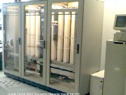
We have also copied the
DSS-2 CD-Rs onto DVD-Rs and placed them into a fast DVD jukebox which
was acquired early 1999. A picture of this installation is shown.
We added a few features to the retrieval software such as: specifying a region around an object name rather than a coordinate pair. This feature was implemented thanks to the SIMBAD interface developed by the CDS in Strasbourg France. We also patch the image headers to include World Coordinate System (WCS) keywords so that a suitable FITS viewer will be able to show celestial rather than pixel coordinates.
If the Digitized Sky Survey southern data was helpful for your research work, the following acknowledgment would be appreciated:
Based on photographic data obtained using The UK Schmidt Telescope. The UK Schmidt Telescope was operated by the Royal Observatory Edinburgh, with funding from the UK Science and Engineering Research Council, until 1988 June, and thereafter by the Anglo-Australian Observatory. Original plate material is copyright (c) of the Royal Observatory Edinburgh and the Anglo-Australian Observatory. The plates were processed into the present compressed digital form with their permission. The Digitized Sky Survey was produced at the Space Telescope Science Institute under US Government grant NAG W-2166.